
A coastal storm moving along the East Coast on Monday will continue to bring the threat of significant coastal flooding, strong to damaging winds and moderate to locally heavy rainfall.
Rain and wind will be dying down Monday morning in the Southeast, while the Northeast will see the worst impacts of the storm through midday.
Rain will become more scattered in the Northeast on Monday afternoon (with locally heavy rain possible at times), before it starts to move out overnight with only a few areas of sprinkles and light rain left for Tuesday morning.
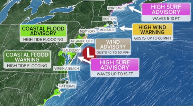
Coastal flood warnings are in effect from North Carolina to Rhode Island, where moderate to locally major flood stages are possible Monday and may persist through Tuesday in some areas.
The worst of the flooding will be around high tide on Monday afternoon (mostly between noon and 3 p.m.), when strong onshore winds will bring water levels 1 to 3 feet above normal levels, leading to flooding and possible dune breaching.
Eight- to 15-foot breaking waves could lead to beach and coastal erosion in areas with coastal flood alerts.
Winds gusted up to 60 mph at Surf City, New Jersey, on Sunday night.
Wind alerts for coastal areas from New Jersey through New York, Connecticut and Cape Cod, Massachusetts, remain in effect Monday due to possible gusts up to 50 to 60 mph.
Rainfall on Monday will mostly be less than 1 inch for New Jersey and New York City, but Long Island, as well as the Hudson Valley up through Albany, could see 1 to 2 inches.
Rhode Island and eastern Massachusetts are also expecting 1 to 2 inches of rain, but some areas of 2 to 3 inches are possible.
Copyright © 2025, ABC Audio. All rights reserved.